Have you ever wondered how many of the world’s political boundaries weren’t drawn by human hands but shaped by nature itself? Among the most fascinating examples are the rivers that form natural borders between nations—mighty waterways that carve out territories, influence cultures, and carry stories older than any country standing today.
From ancient civilizations to modern-day diplomatic strategies, these powerful rivers have quietly remained some of the most reliable and dramatic boundary markers on Earth. And honestly, isn’t it incredible how something as fluid and unpredictable as water can become such a firm line between nations? As you read through, think about this: What would global maps look like if these rivers didn’t exist? Would countries still share the same borders? Would history have unfolded differently?
In this long, engaging exploration, we’ll dive deep into some of the most iconic rivers that shape political geography across continents. But more importantly, we’ll look at the human stories, conflicts, friendships, trade routes, and shared cultures that developed along these natural borders. Because a river is never just a line—it’s life flowing between shores.
The Timeless Importance of Rivers That Form Natural Borders Between Nations
Throughout history, political boundaries have emerged for many reasons: negotiations, wars, treaties, colonization, decolonization, geography, culture, and sometimes pure convenience. But rivers? They’ve always played a special role. They’re visible, distinct, and difficult to dispute—after all, a river flows exactly where it flows.
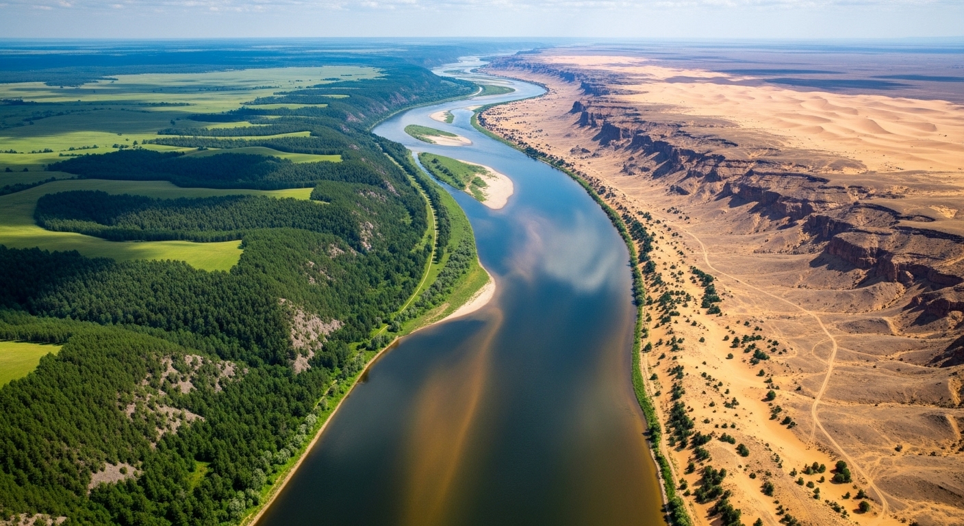
Humans have always relied on natural markers to define spaces. Mountains create walls, deserts create separations, forests create divisions, and coastlines shape identities. But rivers hold a unique place because they are both barriers and bridges. They protect territories, yet also connect cultures. They block movement, yet also encourage trade and travel.
Take a moment to imagine communities living on two sides of a river. They watch the same sunsets, breathe the same air, share the same water source—yet belong to different nations. Isn’t that an intriguing mix of division and unity? That’s the quiet magic behind rivers that serve as borders: they separate countries but rarely separate people.
Why Do Rivers Make Such Effective Borders?
At first glance, the idea seems simple: a river is an obvious line, so why not use it as a boundary? But the reasoning goes deeper than visibility. Rivers serve as political borders for several key reasons:
- They are clearly defined and easily identifiable.
- They act as natural defense barriers.
- They discourage unauthorized crossings in certain areas.
- They reduce confusion during territorial disputes.
- They offer shared resources, encouraging cooperation between nations.
But here’s an interesting twist: rivers are also constantly changing. Some shift courses over decades. Others shrink or expand. Some flood, others dry up. So what happens to the border when the river moves? That question has sparked countless negotiations and conflicts worldwide.
Still, despite their unpredictable nature, rivers remain some of the most iconic and deeply rooted international boundaries on our planet.

The Rio Grande: The Strong, Symbolic Border Between the United States and Mexico
One of the most famous rivers that form natural borders between nations is the Rio Grande, marking roughly 2,000 kilometers between the U.S. and Mexico. The river is more than a boundary—it’s a symbol of shared history, migration, culture, and political debate.
It’s fascinating how the river influences both unity and separation. On the American side, cities like El Paso sit right across from Mexico’s Ciudad Juárez. Despite being in two different countries, the cultures overlap effortlessly—food, music, family ties, celebrations, and lifestyles blend across the riverbanks.
Yet, this same river has also been the center of heated immigration discussions. It carries stories of people seeking new opportunities, families split or reunited, and the complex relationship between neighboring nations.
So ask yourself: What would U.S.–Mexico relations look like without the Rio Grande? Would the boundary feel the same? Would the cultural exchange be as vibrant? Would the political debates be as intense?
The Rhine River: A Historic Divider and Unifier in Europe
Europe’s Rhine River is not just a waterway—it’s a legendary route of trade, culture, conflict, and diplomacy. Serving as a border between Germany and France in several areas, the Rhine has been at the heart of European history for centuries.
Its banks have seen Roman legions, medieval merchants, wartime tensions, and now peaceful cooperation through the European Union. Isn’t it something how a river that once symbolized rivalry between two nations now symbolizes unity, economic strength, and tourism?
The Rhine is a perfect reminder that natural borders don’t always divide—they can help build partnerships that shape entire regions.
The Mekong River: A Powerful, Life-Giving Border in Southeast Asia
Asia’s Mekong River is a powerhouse—flowing more than 4,000 kilometers through six countries. It forms borders between Thailand and Laos, as well as parts of Myanmar. The river sustains millions through fishing, agriculture, and transportation.
But what really makes the Mekong fascinating is the shared responsibility between the nations that rely on it. Water levels, flooding, dam-building, and fish migration are all cross-border issues. So even though the river creates boundaries, it also forces collaboration.
It makes you wonder: Can a river truly divide nations when nature forces them to work together?
The Danube River: Europe’s Bridge Between Many Nations
The Danube is a breathtaking example of how one river can connect more countries than almost any other waterway on Earth. Flowing through 10 nations and forming borders between several, the Danube is less of a divider and more of a global connector.
Yet historically, it has served as a political boundary, military barrier, and natural separator. Today, it’s an economic lifeline and a symbol of unity. From Germany to Ukraine, the Danube touches countless cultures, languages, and traditions.
If you’ve ever traveled along its banks or seen pictures of its stunning landscapes, you know how enchanting this river truly is.

The Amur River: A Remote Yet Mighty Border Between Russia and China
The Amur River forms one of the world’s longest natural borders—separating Russia from China for over 1,600 kilometers. This river has witnessed centuries of diplomacy, tension, trade, and cultural exchange.
Its vast wilderness, forested surroundings, and distance from major cities make it feel timeless. Even today, the Amur remains an area of strategic interest for both nations. Not many borders are as dramatic or untouched by modernization as the Amur.
The River Indus and Its Historical Influence on Border Regions
Though not always used as a modern international border, the Indus River historically shaped boundaries across South Asia. Ancient civilizations built their entire identities around it. Even today, its cultural influence on Pakistan and India remains profound.
Imagine how differently South Asian history would have unfolded without this river guiding early settlements.
More Rivers That Form Natural Borders Between Nations
There are dozens of other major rivers that shape the world map. Some serve as diplomatic lines, some as cultural meeting points, and others as natural shields.
- The Nile River between Sudan and Egypt in certain regions
- The Zambezi River marking borders in Southern Africa
- The Iguazu River forming parts of the border between Brazil and Argentina
- The Orange River between South Africa and Namibia
- The Drina River separating Bosnia and Serbia
Each one has its own stories of alliances, disagreements, shared resources, and deep cultural bonds.
Why Rivers as Borders Matter More Than Ever Today
In a world where borders are continually debated—whether through diplomacy or conflict—the natural boundaries created by rivers provide stability and clarity. Yet they also serve as a reminder of something more meaningful: that countries may be divided, but environments, ecosystems, and resources are shared.
Rivers force us to consider cooperation. They remind us that politics may draw hard lines, but nature ignores them. Fish migrate. Water flows. Floods don’t stop at checkpoints. Environmental concerns don’t need visas.
So perhaps the greatest lesson from rivers that form natural borders between nations is this: We may draw lines on maps, but nature draws the real ones.
After reading this, what do you think about rivers as borders? Do you believe rivers help reduce conflict or create more complications? Have you ever visited a country where a river served as a natural boundary? We would truly love to hear your experiences, opinions, and thoughts—share them in the comments and help others learn from your perspective.
If you enjoy deep, meaningful explorations like this, make sure to follow us on our social media platforms for more fascinating content, global insights, and educational topics that spark curiosity.
Catch up on the top stories and travel deals by subscribing to our newsletter!