
There are few concepts in travel more fascinating than floating border checkpoints in river deltas. Borders are usually imagined as fences, walls, signs, or lines on maps. But in river deltas, borders are fluid, shifting, and often invisible. Here, the boundary between nations drifts with currents, tides, and seasonal floods. Sometimes, the only thing separating two countries is a floating hut, a patrol boat, or a small platform anchored to muddy water.
In a world obsessed with fixed borders, these floating checkpoints challenge everything we think we know about territory and control. How do you enforce a border that literally moves every day? How do you decide jurisdiction when the land itself is constantly changing? And what does it feel like to cross from one country to another without ever stepping on solid ground?
This is the strange, complex, and surprisingly human world of floating border checkpoints in river deltas, where geography, politics, and daily life collide in ways most travelers never imagine.
Why River Deltas Create Border Challenges
River deltas are among the most dynamic landscapes on Earth. They form where rivers meet the sea, depositing layers of sediment that constantly reshape coastlines. Islands appear and disappear. Channels shift. What was land last year may be underwater this year.
This natural instability creates major challenges for borders. Traditional boundary markers simply do not survive in such environments. A border drawn on a map becomes meaningless when the river changes its course. In some regions, entire villages have migrated across international lines without anyone actually moving.
That is why floating border checkpoints exist. Instead of relying on fixed structures, authorities use boats, pontoons, floating offices, and mobile patrol units. The border becomes an operational concept rather than a physical one.
Have you ever thought about how different borders feel when they are enforced by water instead of walls?
The Sundarbans: India and Bangladesh
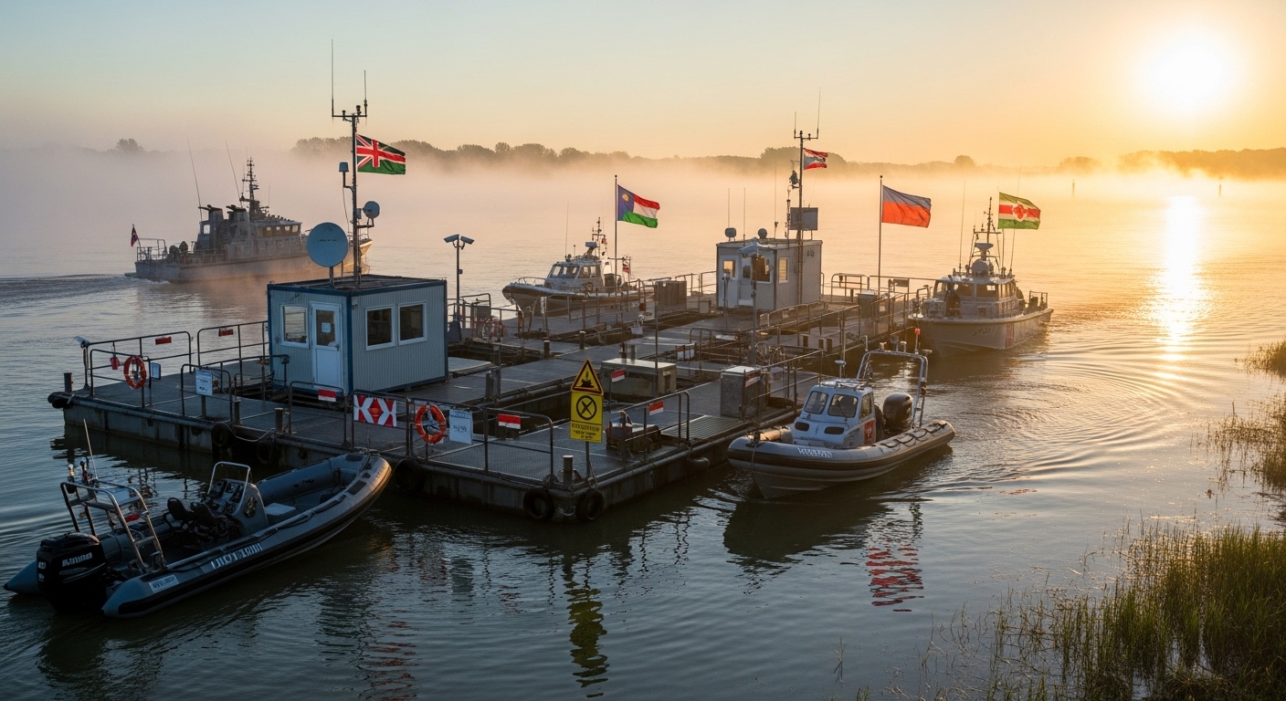
One of the most famous examples of floating border checkpoints in river deltas is found in the Sundarbans, the vast mangrove forest shared by India and Bangladesh. This region is a labyrinth of tidal rivers, creeks, and islands that constantly shift shape.
Here, border patrol officers often operate entirely from boats. Floating platforms serve as customs posts, surveillance points, and rescue stations. Because land is unreliable, everything happens on water.
Locals cross these waters daily for fishing, trade, and family visits. For them, borders are not abstract political concepts but practical realities that affect fuel costs, fishing rights, and even emergency response times.
Information on this region is often highlighted by organizations like UNESCO, which recognizes the Sundarbans as a critical ecological zone. But behind the conservation headlines lies a deeply complex border system that few outsiders ever see.

The Mekong Delta: Vietnam and Cambodia
The Mekong Delta is another powerful example of how floating border checkpoints operate in practice. This massive delta supports millions of people and spans several countries, including Vietnam and Cambodia.
In many parts of the Mekong, border control is conducted almost entirely by river police. Checkpoints are mounted on floating houses, anchored barges, or patrol boats that move with traffic patterns.
Crossing the border here can feel surreal. Instead of walking through a terminal, travelers hand passports to an officer standing on a wooden deck. Stamps are issued while engines idle and water laps against hulls.
Travel platforms like Lonely Planet often describe these crossings as some of the most memorable in Southeast Asia, precisely because they feel so informal yet deeply official.
The Amazon Basin: Brazil, Peru, and Colombia
The Amazon River system contains some of the most ambiguous borders on Earth. In certain areas, three countries meet at points where no permanent land exists. Floating border checkpoints become the only practical solution.
In towns like Tabatinga (Brazil), Leticia (Colombia), and Santa Rosa (Peru), the border is essentially a floating concept. Boats serve as immigration offices. Officers patrol rivers instead of roads.
Here, border enforcement is not just about security. It is about disease control, environmental monitoring, and managing illegal mining and logging activities.
Organizations like the World Bank have studied these regions because river-based borders affect economic development, public health, and infrastructure planning.
The Okavango Delta: Botswana and Namibia
Unlike the crowded deltas of Asia and South America, the Okavango Delta in southern Africa offers a quieter version of floating border checkpoints.
In some areas, Botswana and Namibia rely on water patrols to monitor wildlife trafficking, illegal fishing, and cross-border movement. Floating ranger stations and mobile patrol boats replace traditional border posts.
Because tourism is a major industry here, border enforcement is designed to remain discreet. The goal is to maintain security without disrupting fragile ecosystems.
This balance between control and conservation is often highlighted by environmental groups such as World Wildlife Fund.
Life at a Floating Border
What is daily life like at a floating border checkpoint? It is far less dramatic than movies suggest, but far more complex.
Officers live on boats or floating stations for weeks at a time. Supplies arrive by river. Communication depends on radio and satellite systems. There are no fences, no gates, and often no clear landmarks.
Weather plays a huge role. Storms can shut down operations. Floods can erase entire patrol routes. In some seasons, border enforcement becomes nearly impossible.
For local communities, these checkpoints are not symbols of division but points of connection. They regulate trade, enable travel, and provide emergency assistance.
Have you ever imagined a border officer whose workplace moves several kilometers every year?

Technology and the Future of Floating Borders
Modern technology is reshaping floating border checkpoints. Drones monitor river traffic. GPS systems track patrol zones. Biometric scanners operate on solar-powered boats.
Instead of fixed infrastructure, borders are becoming data-driven. The line is no longer drawn on land but mapped digitally.
This raises new questions. If a border exists mainly in software and satellite systems, what does sovereignty really mean? Can a country control a river that changes its course every decade?
Why Floating Borders Matter in a Changing World
Floating border checkpoints in river deltas offer a preview of the future. As climate change accelerates sea-level rise and increases flooding, more regions will face disappearing land.
Entire coastlines may become unstable. Traditional borders will fail. Floating systems may become the norm rather than the exception.
These places teach us that borders are not natural features of the Earth. They are human agreements imposed on landscapes that do not recognize them.
Perhaps that is what makes floating borders so powerful. They expose the illusion of permanence and remind us that geography always wins in the end.
Reflection for Travelers
Travelers who experience floating border checkpoints often describe them as strangely liberating. There is no gate to pass through, no wall to cross, no line to step over.
Just water, movement, and a quiet moment where identity changes with the flow of a river.
Have you ever crossed a border that felt invisible? Or visited a place where geography seemed more powerful than politics?
We would love to hear your experiences. Share your thoughts, stories, or even questions with WentWorld.com. And if unique travel realities like this inspire you, follow us on our social media platforms for more journeys into the hidden mechanics of our world.
Catch up on the top stories and travel deals by subscribing to our newsletter!


Leave a Reply
You must be logged in to post a comment.